
WINE, SERIOUSLY Profiles Wine in the Hudson Valley
WINE, SERIOUSLY

Wine, Seriously is a wine blog/website about wines from around the world, but wine expert Jose Moreno-Lacalle does an exceptional job of writing very thoroughly about the different regions, especially New York. This piece n the background of wine making in the Hudson Valley presages a series of reviews up-coming from this great new voice in Hudson Valley wine. I strongly urge you to read his blog. - C. DeVito
Viniculture in the Hudson River Region–background
Introduction
The entirety of the Northeast, including New York State, was once covered by Laurentide ice sheets up to nearly two miles thick during the Late Wisconsin Glacial Period, which receded about 11,000 years ago.[1] As the ice sheet melted it reshaped the landscape beneath it that was to take on the features that we know today, and it helped create the Hudson River Valley, leaving behind a complex and varied topography, soil, and climate–the terroir–, much of it appropriate for vine cultivation or other fruit.
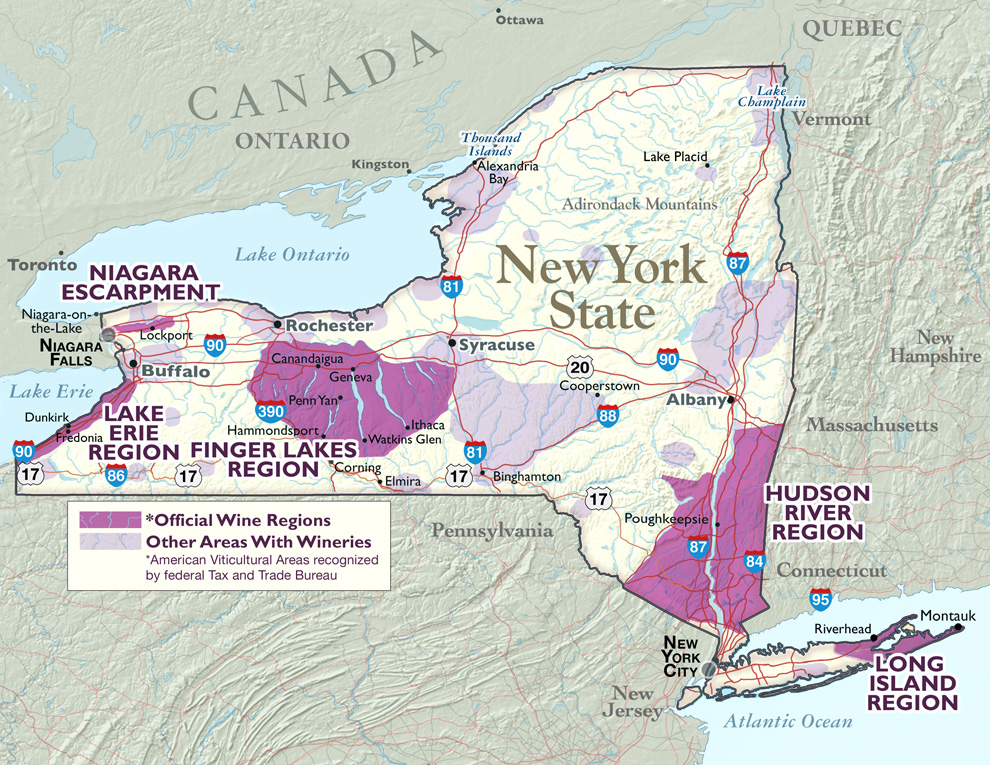
The Hudson River Region AVA is the oldest continually-productive wine region in the United States. Though most people refer to this wine region as the Hudson River Valley or the Hudson Valley, on July 6, 1982 the BATF—in its wisdom—granted the AVA but chose to call it by another name in order to avoid confusion with a winery that already bore the name, Hudson River Valley Winery (no longer in production). If one were to look at different maps that depict the region, its geographical boundaries would not entirely clear, as the maps don’t all agree. (The best one is shown above.) Unfortunately, there is no official AVA map of the region, much less a map for its varied soils and climates. However, it is clearly described verbally in print: its western boundary is the Shawangunk Ridge (a northerly extension of the Appalachians) in Orange and Ulster Counties. It then follows the Delaware River to the New Jersey State line, from which it goes roughly east to its eastern boundary at the state lines with Connecticut and Massachusetts. It then extends north along those borders to the northeast corner of Columbia County, New York. From there it extends west to the juncture of Columbia and Greene Counties in the Hudson River.[2] It includes all or some of several counties: Columbia, Dutchess, Orange, Putnam, Rockland, Sullivan, Ulster, and Westchester.
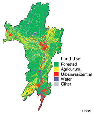
It doesn’t quite encompass all of the Hudson River Watershed, which extends even further north and includes the Mohawk River (see map at left). From this it can be seen, by comparing it to the first map, that while it is primarily geographic, most of its boundaries are political, which is not unusual for AVAs all over the country; however, it also is not strictly based on a homogenous climate or soil types—the terroir—though many of the vineyards are planted on or near the slopes on either side of the Hudson River.
Soil and Terroir
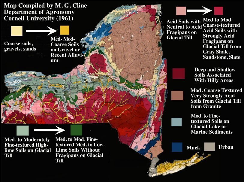 As can be made out from the soil map above, there is a range of soil that include “acid soils with neutral to acid frangipans” (pink color) that runs the length of the river valley, shifting to “medium to moderately coarse-textured acid soils with strongly acidic frangipans on glacial till from gray slate, sandstone, [and] slate” (red color). Contiguous to this is also “deep and shallow soils associated with hilly areas” (dark red). Along the mid to upper-length of the river we see “moderate to fine-textured soils on glacial lake or marine sediments” (pale blue). At the southern limits we see “muck” (dark blue, highly fertile) and “moderately coarse textured, very strongly acid soils from glacial till from granite” (brown color). As grapevines are not fond of acidic soils, this means that many if not most vineyards need alkaline additions such as lime to bring up the soil pH.
The most complete and accessible description of the soils and terrains of the Region may be that of the “New York Wine Course and Reference”, which is worth quoting at length:
A further explanation makes even more clear just how complex the soil profiles of the Region comes from the USDA soil series page:
Indeed, it is the Hudson , with its moderating effect on climate, thanks to the tidal flow and winds that sweep upriver from the Atlantic as well as the so-called “lake effect” (or “river effect” in this case–except in the winter, if the river freezes and is covered with ice) of its wide, deep, flowing stream, that make it possible to grow grapes at all, as it would otherwise be too frigid for most varieties other than the native ones. Its growing season is short: 180 to 195 days. (By comparison, Long Island’s season lasts from 215 to 230 days, while the Niagara Escarpment enjoys 205 days, and the Finger Lakes AVA has 190 to 205 growing days.) Its production is also small, at 585 tons a year (about 2.5 tons an acre), whereas the Niagara Escarpment, with only 6 vineyards and 883 acres produces 4,648 tons (about 5 tons an acre), though some of this is for table grapes, which have much higher yields than do wine grapes.[7]
Read the whole thing at:
http://blogwine.riversrunby.net/viniculture-in-the-hudson-river-region-background/2014/03/14/
The entirety of the Northeast, including New York State, was once covered by Laurentide ice sheets up to nearly two miles thick during the Late Wisconsin Glacial Period, which receded about 11,000 years ago.[1] As the ice sheet melted it reshaped the landscape beneath it that was to take on the features that we know today, and it helped create the Hudson River Valley, leaving behind a complex and varied topography, soil, and climate–the terroir–, much of it appropriate for vine cultivation or other fruit.
1. Map from the Uncorked New York Web site.
The Hudson River Region AVA is the oldest continually-productive wine region in the United States. Though most people refer to this wine region as the Hudson River Valley or the Hudson Valley, on July 6, 1982 the BATF—in its wisdom—granted the AVA but chose to call it by another name in order to avoid confusion with a winery that already bore the name, Hudson River Valley Winery (no longer in production). If one were to look at different maps that depict the region, its geographical boundaries would not entirely clear, as the maps don’t all agree. (The best one is shown above.) Unfortunately, there is no official AVA map of the region, much less a map for its varied soils and climates. However, it is clearly described verbally in print: its western boundary is the Shawangunk Ridge (a northerly extension of the Appalachians) in Orange and Ulster Counties. It then follows the Delaware River to the New Jersey State line, from which it goes roughly east to its eastern boundary at the state lines with Connecticut and Massachusetts. It then extends north along those borders to the northeast corner of Columbia County, New York. From there it extends west to the juncture of Columbia and Greene Counties in the Hudson River.[2] It includes all or some of several counties: Columbia, Dutchess, Orange, Putnam, Rockland, Sullivan, Ulster, and Westchester.
It doesn’t quite encompass all of the Hudson River Watershed, which extends even further north and includes the Mohawk River (see map at left). From this it can be seen, by comparing it to the first map, that while it is primarily geographic, most of its boundaries are political, which is not unusual for AVAs all over the country; however, it also is not strictly based on a homogenous climate or soil types—the terroir—though many of the vineyards are planted on or near the slopes on either side of the Hudson River.
Soil and Terroir
The most complete and accessible description of the soils and terrains of the Region may be that of the “New York Wine Course and Reference”, which is worth quoting at length:
This region crosses five [of the nine New York State] physiographic provinces and is composed of more distinct soil types than any other region. Moving north from Manhattan, the first province encountered is that of the Gneissic Highland Province, a hilly, complex region of highly metamorphosed ancient gneiss. This region encompasses the northern end of Manhattan Island and southern Rockland County, where it forms the Ramapo Mountains. The region continues across the Hudson, and the structure underlies Westchester, Putnam and a small part of southern Dutchess County. The hardness of the bedrock in this area and glacial action have resulted in shallow, rocky soils largely unsuitable for agriculture. Bordering the Gneiss Highland Province to the north is the Taconic Province, an area of lower elevation that extends from Orange County northward through southeastern Ulster County and across the Hudson River, encompassing Dutchess, Columbia, Rensselaer and Washington counties. The rocks in this province are largely shales, slates, schists and limestones, although the northern and eastern areas of Dutchess, Columbia and Rensselaer are underlain with hard metamorphic quartzite and gneiss. The topography of this province varies widely, starting as a valley in southern Orange County and progressing to rolling hills and valleys in the western portions of those counties on the east side of the Hudson, finally culminating the rugged highlands of the Berkshire Mountains in the easternmost section of the province. Given the wide variety of parent material and topography in this province, soil types and suitability to viticulture are extremely varied. Soils in the western portion of this province generally tend to have moisture problems and be low in fertility, although many good sites of limited acreage are under cultivation as orchards and vineyards. Soil conditions improve on the western side of the Hudson, with eastern Dutchess and Columbia Counties possessing the finest sites and consequently the greatest acreage of vineyards. Deep, well-drained soils with adequate moisture holding capacity and low to moderate fertility are present and available in large tracts of land, and offer the opportunity for the expansion of viticulture in the Hudson Valley. Two other physiographic provinces can be included in the Hudson River Region: the Catskill Province which borders the Taconic Province along the dramatic Shawangunk Ridge; and the Mohawk Valley Province which enters the region north of Albany. Neither has significant acreage in grapes, and discussion of the soils of these areas is not relevant to this subject.[3]
A further explanation makes even more clear just how complex the soil profiles of the Region comes from the USDA soil series page:
The Hudson series consists of very deep, moderately well drained soils formed in clayey and silty lacustrine sediments. They are nearly level through very steep soils on convex lake plains, on rolling through hilly moraines and on dissected lower valley side slopes. Saturated hydraulic conductivity is moderately high or high in the mineral surface and subsurface layers and low through moderately high in the lower part of the subsoil and substratum. Slope ranges from 0 through 60 percent. Mean annual temperature is 49 degrees F. and mean annual precipitation is 39 inches.[4]
The Region’s geographic setting is described as follows:
Hudson soils are nearly level to very steep on lake plains and lacustrine capped uplands and valley sides. Slope ranges from 0 through 60 percent. More sloping and dissected areas show evidence of slumping or mass slipping. Mean annual air temperature ranges from 46 degrees to 50 degrees F., mean annual precipitation ranges from 30 through 45 inches, and mean annual frost-free season ranges from 120 through 180 days. The elevation ranges from 50 through 800 feet above sea level.[5]
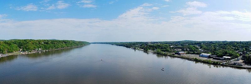
The Hudson River is one of the great waterways of North America, but it only runs 315 miles (507 km.) from its source, Lake Tear in the Clouds, located in Adirondack Park (elevation 1814 ft. (553 m.). It is what is called a ‘drowned river’ in that the waters of the Atlantic Ocean flow upstream with the tide as far as Troy, NY (north of Albany) which means that it is a very long tidal estuary. For this reason it was known to the Lenape tribe that lived along its banks as Muhheakantuck (“river that flows two ways”).[6]Indeed, it is the Hudson , with its moderating effect on climate, thanks to the tidal flow and winds that sweep upriver from the Atlantic as well as the so-called “lake effect” (or “river effect” in this case–except in the winter, if the river freezes and is covered with ice) of its wide, deep, flowing stream, that make it possible to grow grapes at all, as it would otherwise be too frigid for most varieties other than the native ones. Its growing season is short: 180 to 195 days. (By comparison, Long Island’s season lasts from 215 to 230 days, while the Niagara Escarpment enjoys 205 days, and the Finger Lakes AVA has 190 to 205 growing days.) Its production is also small, at 585 tons a year (about 2.5 tons an acre), whereas the Niagara Escarpment, with only 6 vineyards and 883 acres produces 4,648 tons (about 5 tons an acre), though some of this is for table grapes, which have much higher yields than do wine grapes.[7]
Read the whole thing at:
http://blogwine.riversrunby.net/viniculture-in-the-hudson-river-region-background/2014/03/14/
posted by Carlo De Vito | 3:36 PM
![]()
![]()
0 Comments:
Post a Comment
Subscribe to Post Comments [Atom]
<< Home